



Uh oh, the promo has ended
Don't miss out again, get the latest news via
| Starts | 11 Jul 2026 (Sat) | Ends | 25 Jul 2026 (Sat) |
|---|---|---|---|
| Location | Not Specified |
| We are now on Telegram. Click to join |
NDP 2026 road and lane closures will affect the Kallang and National Stadium area on 11 July, 18 July and 25 July 2026
The affected sessions are NE1, NE2 and P1, with closures around Stadium Drive, Stadium Walk, Stadium Crescent, Nicoll Highway, Mountbatten Road, Guillemard Road, Jalan Benaan Kapal and nearby access roads. 🚧
Plan trips early, allow extra travelling time and consider taking MRT or public transport where possible. 🚇🚌
Key dates affected 📅
- 11 July 2026 – NE1 (update: detailed advisory in PDF here)
- 18 July 2026 – NE2
- 25 July 2026 – P1
Road closure timings and affected stretches
| Timing | Affected roads and access points |
|---|---|
| 7am to 11pm |
|
| 2pm to 11pm |
|
| 5pm to 11pm |
|
| 6pm to 11pm |
|
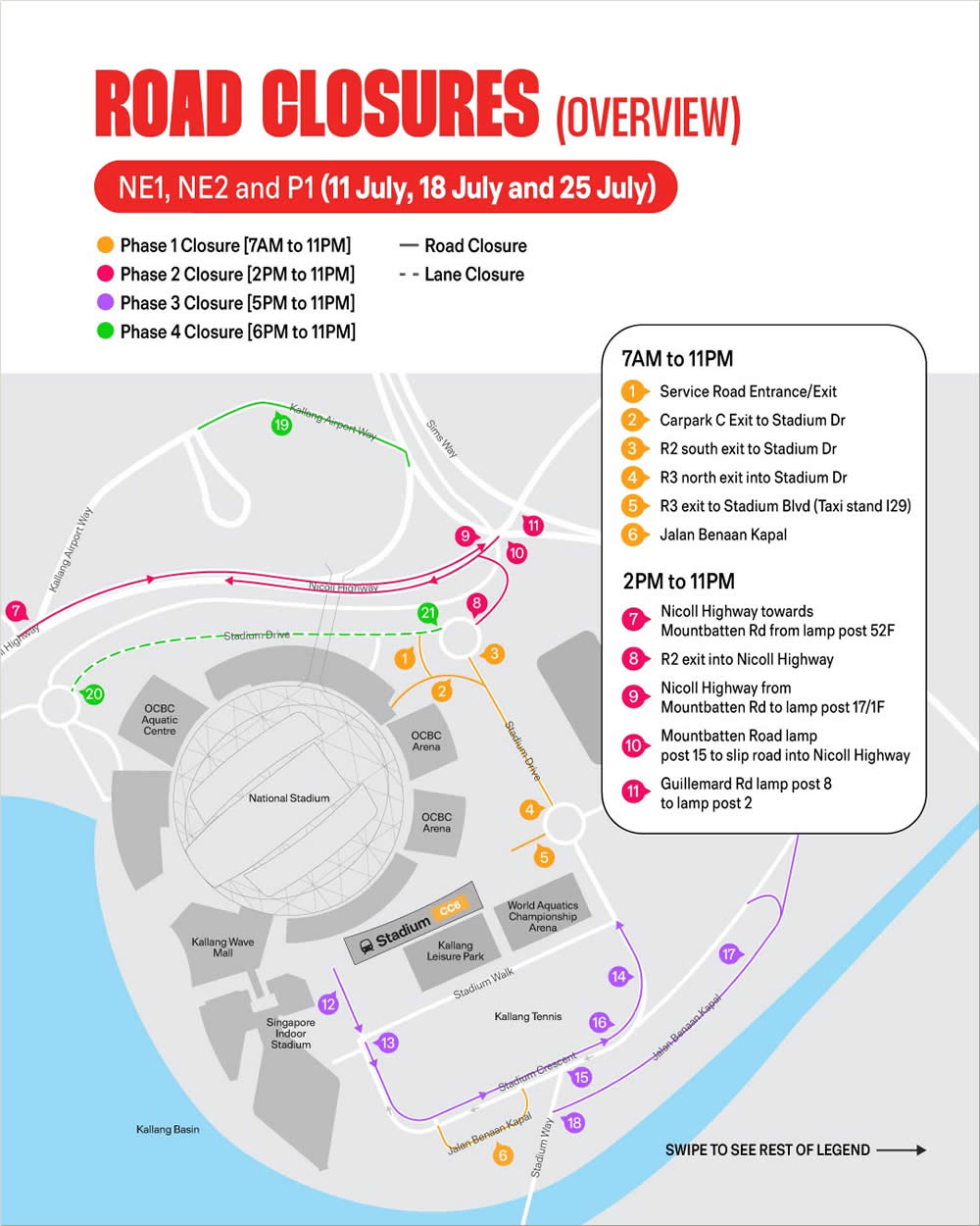
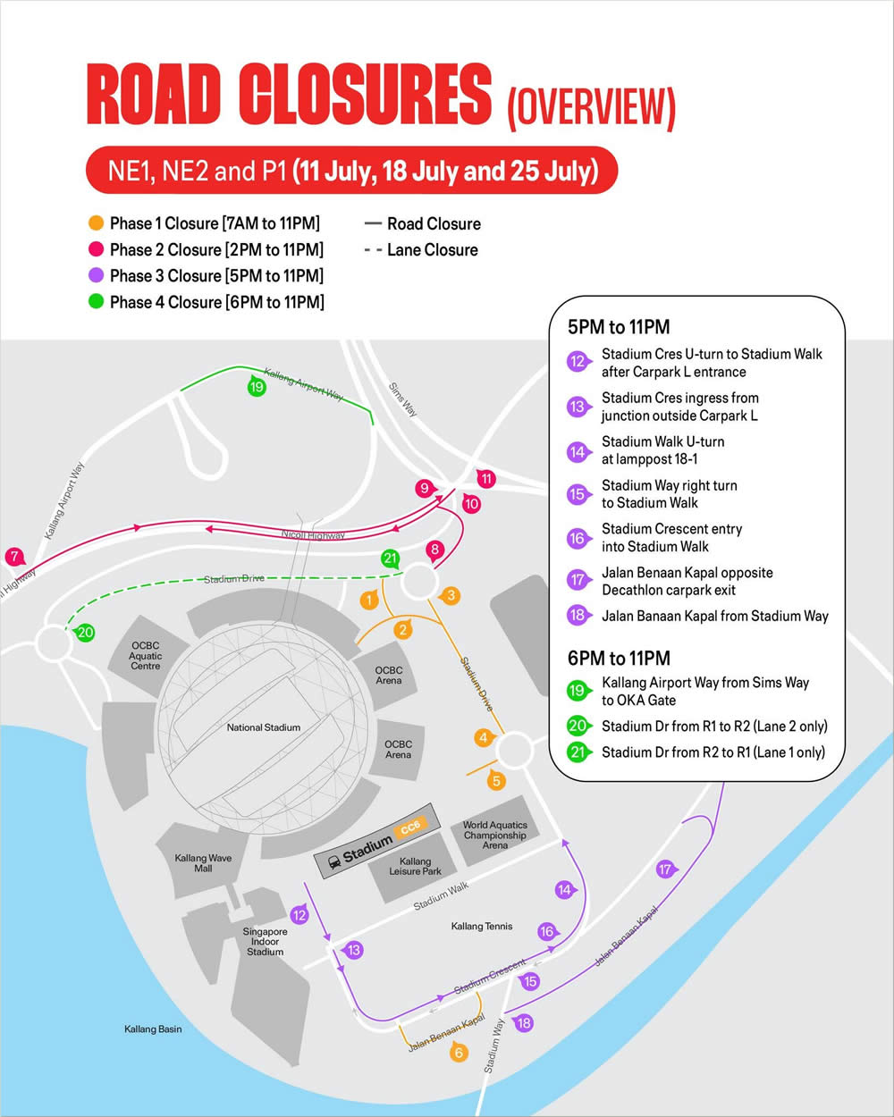
The advisory separates full road closures from lane closures. Solid lines on the map indicate road closures, while dashed lines indicate lane closures. Phase 1 starts from 7am, Phase 2 from 2pm, Phase 3 from 5pm and Phase 4 from 6pm, with all listed restrictions ending at 11pm on each affected date.
Important travel reminders 🚦
- Use Google Maps, Apple Maps or Waze for live traffic updates before setting off.
- Take public transport where possible, especially when heading towards Stadium, Kallang, Mountbatten or Nicoll Highway.
- Parking restrictions along affected roads and lanes will be strictly enforced.
- Drivers should watch for traffic marshals, police directions, barricades and temporary signs around the event area.
- For walking access, bus stop changes, taxi stand updates and accessibility details, check the official NDP 2026 directions page.
Temporary Restricted Areas advisory 🚁
CAAS will establish Temporary Restricted Areas over The Kallang and nearby areas on the affected NDP 2026 dates. For 11 July, 18 July and 25 July 2026, the July TRA windows are 5pm to 7.30pm and 7.30pm to 9pm, covering different TRA maps. The restricted areas extend from ground level to 3,000 feet above mean sea level.
During the stated windows, aerial activities including kite-flying, captive balloons, free-flight aerial objects and unmanned aircraft such as drones are strictly prohibited within the TRAs unless expressly permitted by CAAS. Check the CAAS Temporary Restricted Areas advisory and OneMap before planning any aerial activity near the event area.
Travelling to or around Kallang on the affected dates will require extra planning. Public transport is the smoother option for many commuters, while drivers should check live navigation apps and avoid the restricted roads where possible.
For official updates, visit the NDP 2026 advisories page or refer to the NDP Temporary Restricted Areas advisory (PDF).






Leave a Reply